The third step of Beidou should shock the world —— Revealing the Beidou-3 global networking satellite
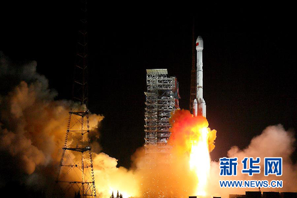
At 19: 45 on November 5th, China successfully launched two Beidou-3 global networking satellites in xichang satellite launch center with the long march 3b. Xinhua News Agency (photo by Yang Zhiyuan)
Xinhua News Agency, Beijing, November 5 th: The third step of Beidou should shock the world — — Revealing the Beidou-3 global networking satellite
Xinhua News Agency reporters Hu Zhe, Bai Guolong and Yu Xiaojie
The third step of Beidou is to shock the world!
On November 5th, the Beidou-3 satellite, which attracted worldwide attention and was expected by Chinese people, kicked off the global networking. According to "18 satellites will be launched around 2018, taking the lead in ‘ Belt and Road ’ Countries along the route provide basic services; In 2020, 35 Beidou satellites will be globally networked and have the ability to serve the world ",and China Beidou is striding towards the world.
How will Beidou-3 achieve the "triple jump" from domestic to regional to global satellite navigation? Where is the technical level leading? What kind of surprises will it bring to the people and the world?
Domestic, regional and global: Beidou navigation realizes historic "triple jump"
"Sina’s shovel, cast it on the ground, its guide." As one of the three major satellite navigation systems in the world, the Beidou satellite navigation system, which roams in the earth orbit, provides regional services from Beidou-1 to Beidou-2, and then to Beidou-3 global network, continuously providing accurate and high-quality services for users.
"You need me, you want me to be excellent, serve human society and benefit the people." Since the Beidou regional navigation system officially provided regional services on December 27th, 2012, the Beidou system has attracted the attention of more and more countries.
In January 2017, the Beidou-2 satellite project won the special prize of the National Science and Technology Progress Award. Yang Hui, chief engineer of the Beidou-2 satellite system of Aerospace Science and Technology Group, said that the Beidou-2 satellite project took eight years to develop and build, and got rid of the dependence on foreign satellite navigation systems and achieved a historic "triple jump".
"China’s Beidou, the Beidou of the world." Is changing from a blueprint to a reality. Xie Jun, deputy chief designer of Beidou-3 project in the Fifth Academy of Aerospace Science and Technology Group and chief chief designer of satellites, said that long before Beidou-2 officially provided regional navigation and positioning services, China started the demonstration and development of Beidou-3 global navigation system, and determined the development goal of building an independent, open, compatible, technologically advanced, stable and reliable global satellite navigation system.
Xie Jun said that compared with the Beidou-2 regional system, the service area of Beidou-3 will be extended to the whole world. At the same time, breakthroughs in key technologies such as upgrading and transformation of downlink navigation signals have been achieved, and a smooth transition with Beidou-2 downlink navigation signals has been achieved. On this basis, new navigation signals have been added to provide users with better services.
It is reported that the construction of high-performance and high-reliability Beidou global satellite navigation system is one of the 16 major national science and technology projects in China’s long-term development plan in the field of science and technology. The system construction is not only the improvement and upgrading of Beidou regional system, but also the focus on the climbing and leaping of world-class satellite navigation system, which will make China’s satellite navigation system reach the international advanced level.
High precision, high reliability and high insurance: there are many things to see in the technological breakthrough of Beidou-3.
Chi Jun, commander-in-chief of Beidou-3 satellite in the Fifth Academy of Aerospace Science and Technology Group, told reporters that once the satellite navigation service fails, not only the economic operation of the country will be greatly affected, but also people’s lives will be greatly inconvenienced, which puts strict demands on the reliability of the satellite navigation system. Generally speaking, Beidou-3 has the characteristics of high precision, high reliability, high insurance and multi-function.
— — High precision. On the basis of the performance of Beidou-2, at the beginning of its design, Beidou-3 focused on the design indicators of the third-generation GPS navigation satellite that has not yet been launched and the European Galileo navigation system.
The positioning accuracy of the Beidou-3 global navigation system will be greatly improved, reaching the level of 2.5 meters to 5 meters. After completion, the Beidou global navigation system will provide civil users with positioning services with an accuracy of about 10 meters and speed measurement services with a speed of 0.2 meters per second free of charge, and will provide services with higher accuracy levels for paying users. The design life of the satellite will reach more than 10 years. With the initial service provided by Beidou ground-based reinforcement system, it can provide meter-level, sub-meter-level, decimeter-level and even centimeter-level services. By then, the accuracy of China Beidou will be comparable to that of American GPS.
— — High reliability. Beidou is a systematic project. Every time users enjoy the service of Beidou system, they must ensure that there are at least 4 satellites to provide services. Beidou is also a global coverage system, which requires at least 20 satellites to provide stable services at the same time. This feature determines that Beidou system requires higher quality reliability and more demanding product reliability than a single satellite. Beidou is still a system whose inherent properties require continuous operation. The signal cannot be interrupted, and the system must be continuous, stable, intact and reliable.
— — High insurance. According to Wang Ping, the chief designer of Beidou-3 satellite in the Fifth Academy of Aerospace Science and Technology Group, Beidou satellite global navigation system is a large-scale system project, and multiple reliability "reinforcement" measures are adopted to maximize the insurance coefficient of the system.
For example, after the completion of the system, the number of operational satellites is greater than the number of satellites necessary for service; At the same time, Beidou-3 satellite also adopted many measures, such as software redundancy, fault self-diagnosis and fault self-repair, to ensure the reliability of the system and greatly enhance the user experience.
— — Multifunctional. China Beidou not only has special functions such as short message, but also can send out the user’s location information, so that others can know the user’s situation, which solves the problem of who, what and where. Combining SMS with navigation is a major feature of Beidou satellite navigation system. A terminal can have both navigation and communication.
Far away? Just around the corner! Beidou service is everywhere.
Ofo sharing bicycles and Beidou Navigation jointly launched the Beidou smart lock; Xiaolan Bicycle uses Beidou ground augmentation system to achieve meter-level positioning, and even in the shade, there will be no "drift" … … In order to report "Where am I?" more accurately, bike-sharing has successively accessed Beidou’s high-precision space-time positioning service.
Bike-sharing is just one of Beidou’s applications that serve people’s livelihood. From emergency rescue and disaster relief to precision agriculture, from fishery broadcasting to smart housing management … … In recent years, various high-precision location service products of Beidou satellite navigation have been widely used in all aspects of national economy and people’s livelihood with the new model of "Beidou+other industries in internet plus".
The recent White Paper on the Development of Satellite Navigation and Location Services Industry in China (2016) shows that the total output value of China’s satellite navigation and location services industry reached 211.8 billion yuan in 2016, an increase of about 22.06% compared with 2015. Beidou contributes 70% to the core output value of the industry, and China’s satellite navigation and location service industry has broad prospects.
"At present, China’s Beidou application has entered a stage of rapid development. With the combination of satellite navigation technology and Internet of Things, big data, cloud computing and other technologies and fields, satellite navigation and location services have become an important strategic emerging industry in China." Min Yiren, deputy director of the National Bureau of Surveying and Mapping Geographic Information, said.
In Qinglan Port, Wenchang, Hainan, Beidou navigation terminal is the standard for fishermen to go out to sea: real-time monitoring of sea operations, alarm at any time when fishing boats are in danger, and listening to weather forecasts and early warning notices at sea. Beidou has become a "clairvoyant", "clairvoyant" and "amulet" in fishermen’s mouth … …
Yu Xiancheng, president of China Satellite Navigation and Positioning Association, said that Beidou technology has jumped out of the category of single navigation technology. Under the urgent demand of urban gas, urban heating, power grid, water supply and drainage and other industries, the National Beidou Precision Service Network has provided Beidou precision services for various industrial applications in more than 400 cities across the country, effectively promoting the optimization and improvement of smart city infrastructure.